Leaflet.geojsonCSS
Geojson CSS implementation for Leaflet.
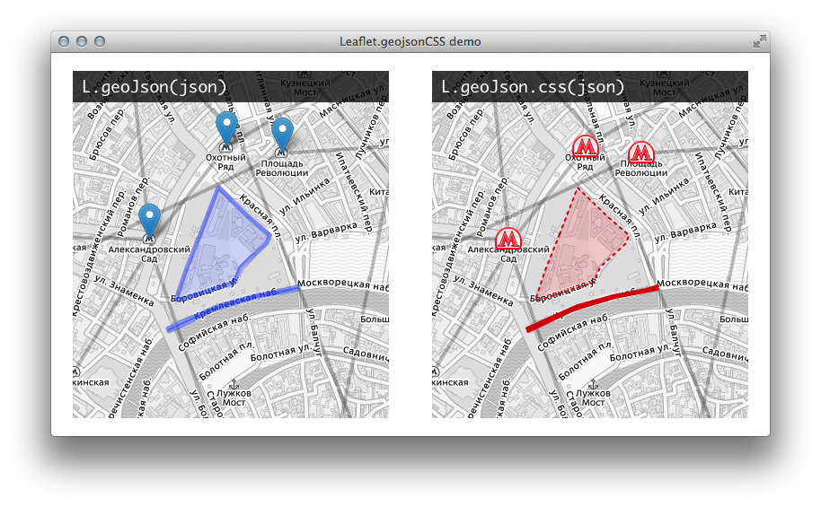
Layer and feature style live demo. Updated to Leaflet 1.3.1

Use L.GeoJSON.CSS or L.geoJson.css instead of L.GeoJSON and L.geoJson:
L.geoJson.css(json).addTo(map);
Install
Download latest release. Use minified or development version.
Or use bower for install:
bower install Leaflet.geojsonCSS --save
Example of GeoJSON with CSS
{
	"type": "FeatureCollection",
	"features": [
		{
			"type": "Feature",
			"geometry": {
				"type": "Polygon",
				"coordinates": [[
					[37.61489152908325,55.752586015356876],
					[37.61577129364014,55.7539867694403],
					[37.616543769836426,55.75506145183324],
					[37.6177453994751,55.75443355110991],
					[37.619526386260986,55.753491681072205],
					[37.62143611907959,55.75252563689488],
					[37.62117862701416,55.75211506087468],
					[37.61875391006469,55.750762544596384],
					[37.61813163757324,55.749989657097],
					[37.61302471160889,55.749035602973365],
					[37.612552642822266,55.74907183330299],
					[37.6134967803955,55.750641781933986],
					[37.61489152908325,55.752586015356876]
				]]
			},
			"style": {
				"color": "#CC0000",
				"weight": 2,
				"fill-opacity": 0.6,
				"opacity": 1,
				"dashArray": "3, 5"
			}
		},
		{
			"type": "Feature",
			"geometry": {
				"type": "MultiLineString",
				"coordinates": [[[37.611907,55.747355],[37.612639,55.747611],[37.613671,55.747839],[37.614446,55.748040],[37.616002,55.748446],[37.616364,55.748537],[37.616573,55.748585],[37.616779,55.748627],[37.617038,55.748677],[37.618375,55.748887],[37.620201,55.749173],[37.620494,55.749215],[37.620723,55.749246],[37.621209,55.749296],[37.622037,55.749388],[37.622402,55.749421],[37.622745,55.749461],[37.622990,55.749484],[37.623206,55.749507],[37.623680,55.749562],[37.624266,55.749640]],[[37.624245,55.749770],[37.623771,55.749678],[37.623476,55.749623],[37.623147,55.749577],[37.621484,55.749414],[37.620021,55.749222],[37.618740,55.749021],[37.617359,55.748819],[37.616927,55.748750],[37.616755,55.748721],[37.616592,55.748691],[37.616413,55.748652],[37.616225,55.748608],[37.614894,55.748251],[37.614139,55.748055],[37.613795,55.747971],[37.613487,55.747906],[37.612526,55.747741],[37.612248,55.747656],[37.611791,55.747497]]]
			},
			"style": {
				"color": "#CC0000",
				"opacity": 1,
				"weight": 4
			}
		},
		{
			"type": "Feature",
			"geometry": {
				"type": "Point",
				"coordinates": [37.61001, 55.752301]
			},
			"style": {
				"icon": {
					"iconUrl": "metro.png",
					"iconSize": [32, 32],
					"iconAnchor": [16, 16]
				}
			}
		}
	]
}
Style properties
For Point geometry use only icon property. Value is an object with Leaflet icon options:
{
	"icon": {
		"iconUrl": "metro.png",
		"iconSize": [32, 32],
		"iconAnchor": [16, 16]
	}
}
For LineString (MultiLineString) and Polygon (MultiPolygon) use Leaflet Path options:
{
	"color": "#CC0000",
	"weight": 2,
	"fill-opacity": 0.6,
	"opacity": 1,
	"dashArray": "3, 5"
}
Popup template
In additional to GeoJSON CSS this plugin support templates for Leaflet.Popup. Use property popupTemplate in features:
{
	"type": "Feature",
	"properties": {
		"title": "Kremlin"
	},
	"geometry": {
		"type": "Polygon",
		"coordinates": [[
			[37.61489152908325,55.752586015356876],
			[37.61577129364014,55.7539867694403],
			[37.616543769836426,55.75506145183324],
			[37.6177453994751,55.75443355110991],
			[37.619526386260986,55.753491681072205],
			[37.62143611907959,55.75252563689488],
			[37.62117862701416,55.75211506087468],
			[37.61875391006469,55.750762544596384],
			[37.61813163757324,55.749989657097],
			[37.61302471160889,55.749035602973365],
			[37.612552642822266,55.74907183330299],
			[37.6134967803955,55.750641781933986],
			[37.61489152908325,55.752586015356876]
		]]
	},
	"style": {
		"color": "#CC0000",
		"weight": 2,
		"fill-opacity": 0.6,
		"opacity": 1,
		"dashArray": "3, 5"
	},
	"popupTemplate": "<strong>{title}</strong>"
}